In the summer of 2026, Canada is burning.
Not metaphorically. Not in isolated pockets. From coast to coast — from the Atlantic shores of Nova Scotia to the Pacific mountains of British Columbia, from the southern farmlands of Saskatchewan to the sub-Arctic wilderness of the Northwest Territories — more than 950 fires rage simultaneously, and 700 of them are classified as out of control.
As of late July 2026, the season has consumed approximately 3 million hectares — 7.4 million acres — of boreal forest, wetland, and scrubland. More than 3,800 fires have ignited since spring. Forty-four First Nations communities have been affected. Over 4,300 people have been displaced. The smoke has crossed every border, turning the skies of New York, Chicago, and Washington orange, and reaching as far south as Mexico.
This is not an anomaly. It is the fourth consecutive above-average Canadian fire season — following the all-time record of 2023, an elevated 2024, and the second-worst season in recorded history in 2025. The boreal forest is being redrawn in real time.
A Country Built on Fire
To understand the 2026 crisis, you have to understand that fire is not new to Canada's boreal forest. The boreal zone — the vast belt of coniferous forest stretching across the country's northern third — evolved with fire. Indigenous peoples have used controlled burns for thousands of years to manage land, encourage berry growth, and renew pasture for wildlife. Lightning-sparked fires have shaped the forest's age structure and biodiversity for millennia.
What has changed is the scale, the frequency, and the intensity.
Canada's modern wildfire record begins in earnest with the 1910 "Year of Fires" across Ontario and Quebec. The Matheson Fire of 1916 in northern Ontario killed 223 people — still one of the deadliest natural disasters in Canadian history. The Porcupine Fire of 1911 burned nearly half a million hectares and destroyed multiple communities. For the first half of the 20th century, massive fire seasons were an occasional catastrophe, not an annual expectation.
That calculus began shifting visibly in the 1980s and 1990s. The Canadian Forest Service documented an increase in the size of individual fires, the length of the fire season, and the geographic range of extreme fire conditions. Climate scientists identified the mechanism: rising temperatures extend the window of hot, dry weather; beetle infestations (themselves driven by warmer winters) kill vast stands of trees and leave standing fuel; and drought cycles grow more severe.
The inflection point — the moment the old patterns broke permanently — came in 2023, when Canada burned 18.5 million hectares in a single season. That number obliterated every previous record by a factor of nearly three. It was the worst wildfire season in Canadian recorded history by an enormous margin. And it was followed by two more severe seasons before 2026 even began.
How 2026 Ignited
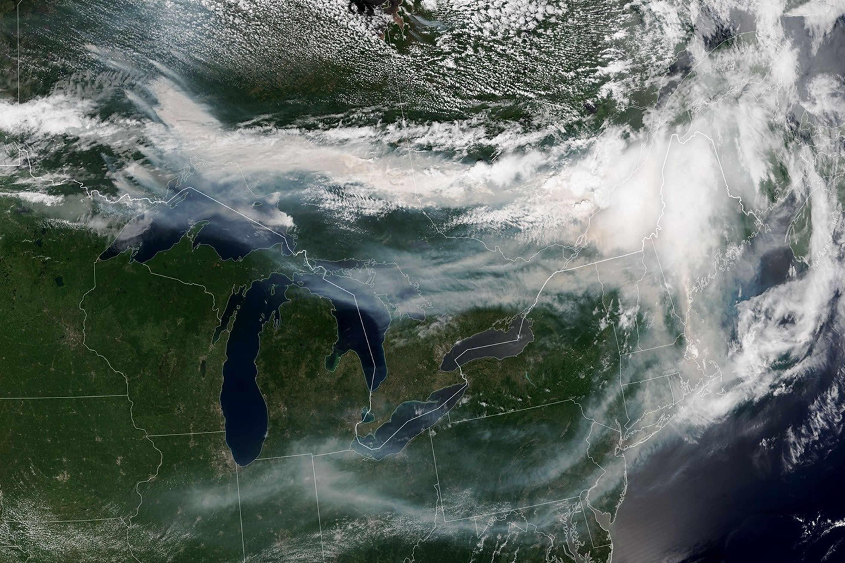
The 2026 season opened quietly. Spring rains kept fire danger suppressed through May and into early June. Fire managers cautiously noted the healthy soil moisture readings and hoped for a moderate year.
Then the lightning came.
In the final week of June and the first two weeks of July, a series of powerful thunderstorm systems swept across northern Ontario, northern Quebec, and the Northwest Territories. The storms brought almost no rain — just lightning. Tens of thousands of strikes ignited fires simultaneously across landscapes that the recent heat had rapidly dried to tinder.
The critical date was July 12, 2026. In Wabakimi Provincial Park, in the remote wilderness of northwestern Ontario, several fires ignited within hours of each other. By the next morning, they had merged. By July 14, what fire managers were calling Thunder Bay 36 covered more than 100,000 hectares. By July 20, it had grown to more than 350,000 hectares — one of the largest fires in Ontario's recorded history, and still out of control.
Meanwhile, in the Northwest Territories, lightning-caused fires exploded around Norman Wells and along the Great Bear Lake corridor. In Saskatchewan, the Lobstick Fire consumed 19,000 hectares before crews could establish containment lines. In Manitoba, fires swept toward First Nations communities with no road access. In Nova Scotia, a wildfire northeast of Halifax claimed the life of a firefighter — the season's first death — on May 21.
By mid-July, fire management systems across the country were overwhelmed. Canada's five major fire management regions — British Columbia, the Prairies, Ontario, Quebec, and the Atlantic — were all simultaneously active. Interprovincial mutual aid agreements were invoked. The federal government leased additional aircraft and deployed military assets. And still the fires grew.
The Night the Satellites Saw Fire
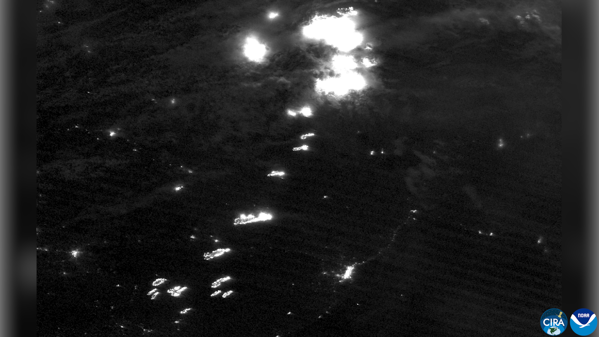
The NOAA-20 satellite image captured on the night of July 14, 2026, became one of the defining images of the season. In an image normally dominated by the glowing grid of human settlement — the lights of Toronto, Thunder Bay, Sudbury, Sault Ste. Marie — something else dominated the frame.
Fire.
Hundreds of thermal hotspots — orange pinpoints of intense heat — blanketed northwestern Ontario. The VIIRS (Visible Infrared Imaging Radiometer Suite) instrument had detected fires burning with enough intensity to register clearly from 800 kilometres above Earth. Where there should have been darkness, there was a constellation of flame.
This single image encapsulates the 2026 fire season's character: not one catastrophic fire, but hundreds of simultaneous ignitions across a landscape so vast that no human response could address them all at once. Fire managers were forced to triage — protecting populated communities and critical infrastructure while allowing fires in remote wilderness to burn unchecked.
What Is Burning, and Why It Matters
Canada's boreal forest is not simply trees. It is one of the largest intact ecosystems on Earth — a carbon sink of enormous global importance. The boreal stores an estimated 208 billion tonnes of carbon in its soils, peatlands, and vegetation. When it burns, that carbon is released into the atmosphere, accelerating the very conditions that make future fires more likely and more severe.
The fires of 2026 are burning through landscapes that burned severely in 2023 and 2024 and 2025. This is unusual. Historically, boreal fires created a patchwork of burn ages — some areas freshly burned, others decades old, others centuries old. The diversity of ages meant diverse fuel conditions, which naturally limited fire spread. Consecutive fire seasons in the same areas are burning through that buffer, creating vast stretches of uniformly young, dense, highly flammable vegetation.
Scientists at the Canadian Forest Service have begun describing this as a fire regime shift — a fundamental change in how fire behaves in Canada's north, driven by climate conditions that now exceed the historical range of variability. The forest is not simply burning more. It is burning differently, in ways that the existing fire management system was not designed to handle.
Fleeing the Flames
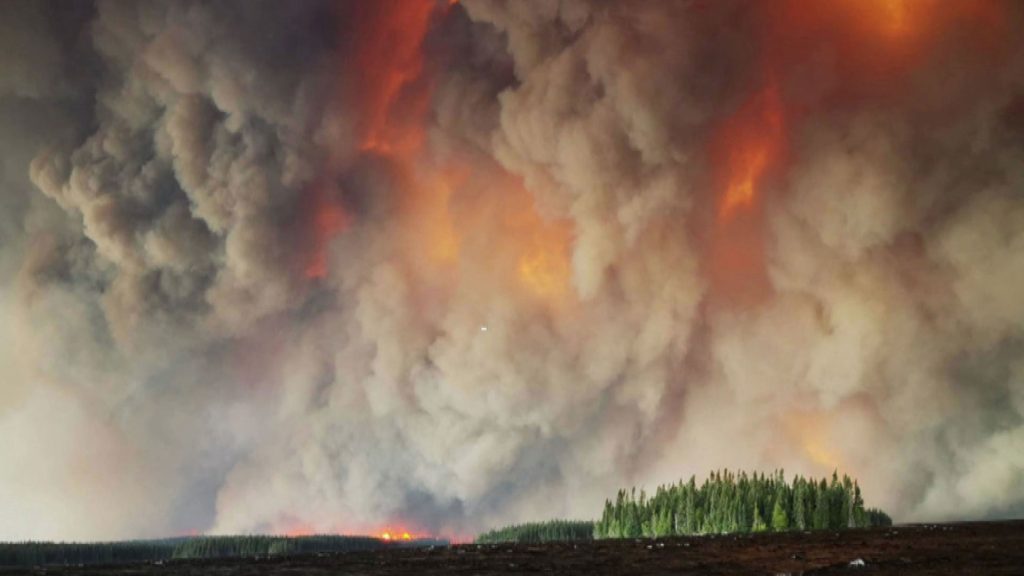
The human cost of the 2026 season has fallen hardest on Canada's First Nations communities — a pattern that has repeated in every recent fire season and reflects both geography and systemic inequity.
Many First Nations communities in northern Ontario, Manitoba, and the Northwest Territories sit in landscapes that are among the most fire-prone in the country. They often lack road connections to southern population centres, making evacuation logistically complex and extremely expensive. Infrastructure is frequently older and less fire-resistant than in southern cities. And the social and cultural disruption of evacuation — leaving traditional territories, being housed in distant cities, separated from elders and community — carries costs that extend far beyond the physical.
Since April 1, 2026, 44 First Nations communities have been affected by wildfire activity. More than 4,300 First Nations individuals have been evacuated. As of mid-July, more than 1,500 remained displaced, unable to return to their homes.
The community of Namaygoosisagagun First Nation in Manitoba was not merely evacuated — it was largely destroyed. The community of Fort Simpson in the Northwest Territories — 1,300 residents — evacuated completely when fire threatened to encircle the town. Wrigley, a community of 130, followed. The Canadian Armed Forces deployed CC-130J Hercules transport aircraft to airlift residents from communities that had no other way out.
The mandatory evacuation orders extended to non-Indigenous communities as well — Armstrong in Ontario, communities in the Shellbrook area of Saskatchewan, residents of West Kelowna in British Columbia facing the Kalamoir Park Fire.
Fire Meets Steel
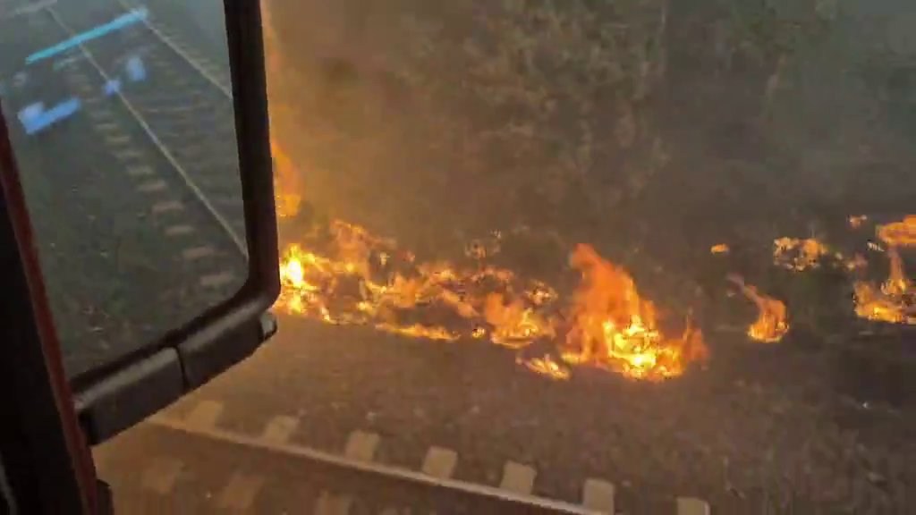
On July 15, 2026, a Canadian National freight train found itself in the wrong place as the Thunder Bay 36 complex swept across the rail corridor near Armstrong, Ontario. Onboard cameras captured the moment the forest on both sides of the tracks ignited simultaneously — a wall of orange and black closing in from every direction.
The crew evacuated safely. The footage did not stay local. Within hours, it was circulating globally — a visceral, comprehensible image of what fire on this scale actually looks like from the inside. Not a satellite image. Not a bar chart. A train surrounded by an inferno, and people running.
The Armstrong rail corridor is a critical freight link for northern Ontario. Its temporary disruption during the peak of the fire crisis added supply chain complications on top of the human emergency.
When the Smoke Crossed Every Border
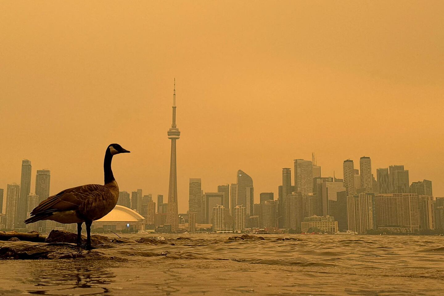
On July 15, 2026, a child in Toronto stepped outside for the first time and asked why the sky was orange.
It was a question being asked simultaneously from Thunder Bay to New York City, from Chicago to Washington D.C. The smoke from Ontario's fires had not merely drifted south. It had descended — trapped at ground level by atmospheric conditions that prevented the usual vertical dispersion — and covered the eastern half of North America in a haze that turned afternoon sunlight the colour of a furnace.
Toronto recorded the worst air quality of any major city in the world on July 15, 2026. Environment Canada's Air Quality Health Index hit 10+ — its maximum "Very High Risk" classification — across the Greater Toronto Area. Thirty-six people were admitted to Toronto hospitals with smoke-related respiratory distress on that single day. Outdoor events were cancelled. Schools kept children inside. Workers wore N95 masks on sidewalks.
But Toronto was not the worst-affected location. That distinction went to areas closer to the fire sources.
In Virginia, air quality monitors recorded an AQI of 1,615 — more than 30 times the "Good" threshold of 50. In the Thunder Bay border region, readings reached 1,587. In Saginaw, Michigan, 1,135. Across New York, Wisconsin, Minnesota, and the Midwest, health advisories recommended that vulnerable populations stay indoors entirely. Light-density smoke was tracked by satellite as far south as multiple Mexican states.
The smoke became a continental event — a reminder that Canada's fire crisis had consequences that extended far beyond its borders, and that the question of what happens to the boreal forest is not only a Canadian question.
The Aerial Battle
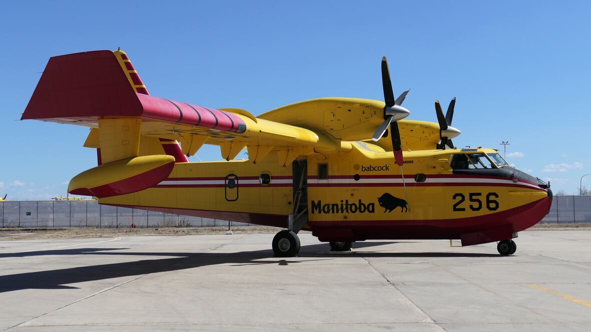
Against fires of this scale, the aerial response is both heroic and humbling.
Canada's fleet of water bombers, airtankers, and helicopters represents one of the most specialized and capable aerial firefighting forces in the world. These aircraft — many of them designed specifically for fire suppression — can carry thousands of litres of water or fire retardant, operating in conditions of smoke and turbulence that would ground most commercial aircraft.
In 2026, they are simply outnumbered.
The federal government has leased 10 additional aircraft — 4 airtankers, 1 spotter plane, and 5 helicopters — and pledged $47.8 million for wildfire preparedness. Manitoba committed $80 million for the purchase of 3 new water bombers. Nova Scotia expanded its aerial fleet. And still, with 700 fires simultaneously out of control, the mathematics are unforgiving. You cannot put a water bomber over every fire at once.
Crews are prioritizing. Communities first. Critical infrastructure second. Wildland fires in uninhabited areas — however large — receive limited suppression effort. The strategy is not to defeat these fires. It is to guide them away from people and let them burn out when conditions change.
A Reckoning Five Seasons in the Making
The 2026 season does not exist in isolation. It is the fifth act of a drama that has been building since the mid-2010s, and the fourth consecutive chapter of a new and alarming norm.
| Season | Classification | Notable Events |
|---|---|---|
| 2022 | Above average | Multiple provincial emergencies; elevated activity across the west |
| 2023 | ALL-TIME RECORD | 18.5 million hectares — nearly 3× any previous year; Fort Nelson, Yellowknife evacuations |
| 2024 | Above average | Sustained elevated conditions; multiple major evacuations; Alberta and BC hardest hit |
| 2025 | Second-worst on record | Massive fires in BC, Alberta, Ontario; international firefighting assistance requested |
| 2026 | Above average (ongoing) | ~3 million ha as of late July; 950+ active fires; smoke reaches Mexico |
The pattern is not ambiguous. Canada's fire regime has fundamentally changed. The question — debated by scientists, governments, and Indigenous communities — is what to do about it.
Proposed responses range from the immediate (more aircraft, more firefighters, better early warning systems) to the structural (prescribed burning at scale, forest management reforms, land use changes near communities) to the systemic (greenhouse gas emissions reductions sufficient to slow the underlying climate forcing). Most experts argue that all three levels of response are necessary, and that the country is currently adequate only at the first level.
The AI-powered wildfire detection cameras being tested in Alberta in 2026 represent a promising step — early detection can mean the difference between a small fire and an uncontrollable one. But detection alone does not suppress fire, and the suppression capacity of Canada's firefighting system has not kept pace with the growth of the threat.
What History Will Record
Historians of future decades, writing about the early 21st century, will likely identify the 2023–2026 wildfire seasons as the moment Canada's relationship with its own landscape was fundamentally redefined.
They will note the satellite images — the orange constellations of fire visible from orbit; the brown smoke plumes streaming across a continent. They will note the trains surrounded by flame, the communities airlifted to safety, the streets of Toronto and New York City turned orange by smoke from forests 2,000 kilometres away. They will note the statistics — 18.5 million hectares in 2023; 3 million and counting in 2026 — and the scientists who had been warning of exactly this trajectory for decades.
They will note that the communities that suffered most were the ones that had been warning about land and climate for the longest time.
And they will ask: what did we do when we knew?
Key Statistics — 2026 Season
- Total fires recorded (season to date): 3,787–3,888
- Currently active fires: 950+ (700+ out of control)
- Total area burned: ~3 million hectares (7.4 million acres)
- Provinces and territories affected: All 9 provinces + all 3 territories
- First Nations communities impacted: 44 (since April 1)
- People evacuated: 4,300+ First Nations individuals; thousands more non-Indigenous
- Still displaced as of mid-July: 1,500+
- Deaths: 4 (1 firefighter in Nova Scotia, 3 in plane crash near Fort Simpson)
- Largest single fire: Thunder Bay 36, Wabakimi Provincial Park — 318,813–350,922 ha
- Toronto peak AQI, July 15: Worst of any major city in the world
- Peak US AQI (Virginia): 1,615 — 30× the "Good" threshold
- Federal response funding: $47.8 million pledged
- Additional aircraft leased: 10 (4 airtankers, 1 spotter, 5 helicopters)
Sources
- Government of Canada — 2026 Wildfire Season Update (canada.ca)
- Wikipedia — 2026 Canadian Wildfires (en.wikipedia.org)
- CBC News — Wildfires Canada 2026 Tracker (cbc.ca)
- CTV News — Where Wildfires Are Burning / Evacuations Ordered (ctvnews.ca)
- NASA Earth Observatory — Ontario Wildfire Smoke Moves East (science.nasa.gov)
- NASA Earthdata — Dense Smoke from Wildland Fires in Ontario (earthdata.nasa.gov)
- IQAir — Northwestern Ontario Wildfire Map Spotlight (iqair.com)
- FireRadar.ca — Ontario Wildfire Map (fireradar.ca)
- Canadian Wildland Fire Information System / CWFIS (cwfis.cfs.nrcan.gc.ca)
- Zoom Earth — Thunder Bay 36 Fire (zoom.earth)
- Medical Daily — 2026 Wildfire Season Statistics (medicaldaily.com)
- Fast Company — Canada Wildfires Maps (fastcompany.com)
- Global News — BC Wildfire Map 2026 (globalnews.ca)